160
160
Oct 11, 2012
10/12
by
KRCB
tv
eye 160
favorite 0
quote 0
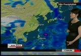
heaviest rain is going to be found bangladesh, northeastern india, as well as the northern half of myanmar. out toward the east we're still monitoring prapiroon. the eastern half of taiwan, as well as okinawa islands, waves could reach five meters today. if it's going to continue to move at a slow pace. so again, rough seas could continue and it could move through the okinawa islands or taiwan early next week. we'll keep you posted on the storm's progress. temperatures are looking like this. quite warm for this time of year. tokyo out 26 degrees. looking at 19 degrees in seoul. out towards the west, 8 degrees in ulan bator. should be cooling down into minus 2 degrees as we head into your friday. alright, finally let's go over to the americas, then. lots of wintry precipitation across canada. this low has been dumping heavy snow in southern quebec and parts of other the rest of quebec. back behind it another system is also producing snow. that's going to head toward southern ontario. we'll see as much as 20 centimeters of snowfall here. even northern parts of minnesota may be seeing a mixtu
heaviest rain is going to be found bangladesh, northeastern india, as well as the northern half of myanmar. out toward the east we're still monitoring prapiroon. the eastern half of taiwan, as well as okinawa islands, waves could reach five meters today. if it's going to continue to move at a slow pace. so again, rough seas could continue and it could move through the okinawa islands or taiwan early next week. we'll keep you posted on the storm's progress. temperatures are looking like this....
239
239
Oct 10, 2012
10/12
by
KCSMMHZ
tv
eye 239
favorite 0
quote 0
today the heaviest rain is found in the northern half of myanmar. out east we can see this pink showing up. typhoon praphoon starting to produce rough seas. over eastern taiwan from late tonight. waves could reach four meters. as you can see, it's going to continue to move at a slow pace over the next several days. we're not sure where the system is going. it could move through the okinawa islands. we'll keep you posted on the storm's progress. temperatures are looking like this. we're expecting 19 degrees in seoul on wednesday. that's about three degrees lower than yesterday. tokyo slightly warming up to 24 degrees. and out west, 19 in chongqing and dropping out of the 30s in hong kong. all right. moving into the americas then. lots of snow in canada. this low pressure system moving across eastern canada is spreading rain and snow in ontario and northern quebec. and rain showers in the great lakes. the symptom will travel towards the east. and will start to effect new england and the east end of canada on wednesday. and back behind it there's anoth
today the heaviest rain is found in the northern half of myanmar. out east we can see this pink showing up. typhoon praphoon starting to produce rough seas. over eastern taiwan from late tonight. waves could reach four meters. as you can see, it's going to continue to move at a slow pace over the next several days. we're not sure where the system is going. it could move through the okinawa islands. we'll keep you posted on the storm's progress. temperatures are looking like this. we're...
233
233
Oct 11, 2012
10/12
by
KCSMMHZ
tv
eye 233
favorite 0
quote 0
today the heaviest rain is going to be found bangladesh, northwestern india, and myanmar. northwest, monitoring the typhoon. it will continue to move at a slow pace, that means rough sea conditions will prolong across luzon, the eastern half of taiwan, as well as okinawa islands. waves could reach 5 meters today. and it's going to continue to move at a slow pace, so again, rough seas conditions will continue. and it could move through the okinawa islands or taiwan early next week. we'll keep you posted on the storm's progress. temperatures are looking like this. quite warm for this time of year, tokyo at 26 degrees. looking at 19 degrees in seoul, but out towards the west, 8 degrees, should be cooling down into minus 2 degrees as we head into your friday. all right, finally let's go over to the americas. lots of wintery precipitation across canada, but this low has been dumping heavy snow in southern kwoou beck and other parts of kwoou beck. as much as 20 centimeters of snowfall here, north dakota and minnesota may be seeing a mixture of rain and snow. down towards the sou
today the heaviest rain is going to be found bangladesh, northwestern india, and myanmar. northwest, monitoring the typhoon. it will continue to move at a slow pace, that means rough sea conditions will prolong across luzon, the eastern half of taiwan, as well as okinawa islands. waves could reach 5 meters today. and it's going to continue to move at a slow pace, so again, rough seas conditions will continue. and it could move through the okinawa islands or taiwan early next week. we'll keep...
WHUT (Howard University Television)
231
231
Oct 10, 2012
10/12
by
WHUT
tv
eye 231
favorite 0
quote 0
day the heaviest rain is going to be found across the northern half of myanmar. well out toward the east, monitoring the typhoon prapiroon, it will become a strong typhoon in the next 24 hours. conditions starting to affect the coast of northern luzon, and taiwan, and okinawa islands. waves could reach 4 meters. not sure where the system is going. there is a possibility it could move through the okinawa islands next week. keep you posted on the storm 's progress. heading towards the americas, series of low-pressure systems moving through canada, producing snow showers. the low is producing early season snowen ein ontario. cold across the great lakes. that will move across the east, new england, eastern end of canada will be affected by the storm wednesday. back behind it, the system, the system is producing -- snow showers in alberta. that is going to head towards the east. as the it does, southern matitoba will see the heaviest snow wednesday the we anticipating as much as 15 centimeters of snow to fall across these region. even northern parts of north dakota an
day the heaviest rain is going to be found across the northern half of myanmar. well out toward the east, monitoring the typhoon prapiroon, it will become a strong typhoon in the next 24 hours. conditions starting to affect the coast of northern luzon, and taiwan, and okinawa islands. waves could reach 4 meters. not sure where the system is going. there is a possibility it could move through the okinawa islands next week. keep you posted on the storm 's progress. heading towards the americas,...
429
429
Oct 10, 2012
10/12
by
KCSM
tv
eye 429
favorite 0
quote 1
tropical storm are still hovering over the sea and today the heaviest rain is in the northern half of myanmar and out east we can see this showing up, typhoon is still hovering over the western pacific and starting to produce at rough seas across the coast and east of taiwan and the southern islands of japan like the okinawa islands from late tonight. waves could reach 4 meters. it is going to continue to move a slow pace over the next several days. we're not sure where it is going but there is a small possibility it could move through the okinawa islands next week. we'll keep you posted. temperatures are looking like this. we're expecting 19 degrees in seoul on wednesday and that is about 3 degrees lower than yesterday. tokyo slightly warming up to 24 degrees and out west 19 in chong ching and dropping out of the 30s in hong kong. moving into the americas, lots of snow in canada. this low pressure system is spreading rain and snow in ontario and northern quebec and rain showers in the great lakes where the system will travel towards the east and start to affect new england and the east end o
tropical storm are still hovering over the sea and today the heaviest rain is in the northern half of myanmar and out east we can see this showing up, typhoon is still hovering over the western pacific and starting to produce at rough seas across the coast and east of taiwan and the southern islands of japan like the okinawa islands from late tonight. waves could reach 4 meters. it is going to continue to move a slow pace over the next several days. we're not sure where it is going but there is...
98
98
Oct 25, 2012
10/12
by
CSPAN2
tv
eye 98
favorite 0
quote 0
trans-pacific partnership and who has diplomatic elements in the opening of a new relationship with burma and myanmar that hillary clinton highlighted on her trip and the decision to join the east asia soudet summit, something the previous administration hadn't done and this is likely to be premier institution in the world in the years to come and president obama decided that we had to be in that to help shape that. >> thank you the rematch. the second question is going to jeff. both candidates have expressed the desire to seek the best possible relationship with china. what means with each of your candidates adopt to accomplish this and what are the limits they foresee in building such a partnership or positive relationship? what are two areas, specific areas your candidate sees as having the greatest potential for cooperation? >> we have had for years to demonstrate how we are going to conduct the relationship and hope for a second term. i would say that the key elements, the balance between a strong and positive relationship with china combined with strong and powerful relations with our partners
trans-pacific partnership and who has diplomatic elements in the opening of a new relationship with burma and myanmar that hillary clinton highlighted on her trip and the decision to join the east asia soudet summit, something the previous administration hadn't done and this is likely to be premier institution in the world in the years to come and president obama decided that we had to be in that to help shape that. >> thank you the rematch. the second question is going to jeff. both...
 Live Music Archive
 Librivox Free Audio
 Metropolitan Museum
 Cleveland Museum of Art
 Internet Arcade
 Console Living Room
 Books to Borrow
 Open Library
 TV News
 Understanding 9/11